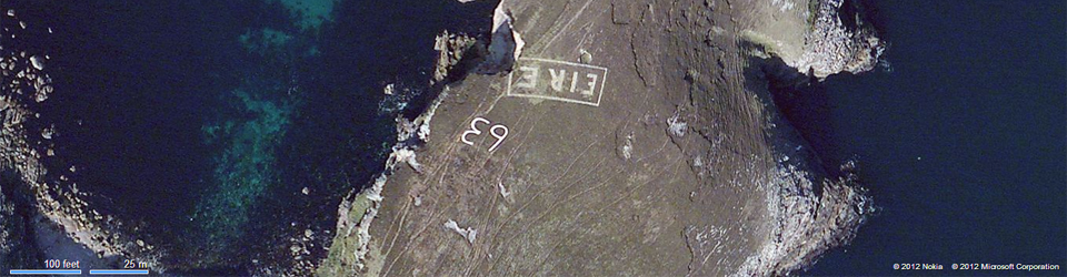
UPDATE: EIRE7 – Dalkey – 20 May 2019
Dalkey Tidy Towns have come together and renovated the sign near Dalkey. This is really fantastic as when I started this project way back, all I could find on the east coast was some remnant of the signage at the foot of Wicklow Head. So it’s really great that at the moment, we have Dalkey restored, Bray Head currently visible, and we know the location in Howth, I also know that a number of people are interested in getting Howth restored as well.
UPDATE: EIRE79 – Fanad Head – 21 September 2018
The location for Fanad Head’s sign was identified via aerial photography done by TG4. From the photographs I’ve seen, the 9, and probably part of the frame are currently visible, but little else. I suspect this sign reappeared as a result of the weather in Ireland in summer 2018 and looking at the aerial photographs I used for the original search a few years ago, the sign is not visible on any of them. There is some evidence of stones in the area in the 1995 OSI photographs however, and from what I can ascertain, they align with the location of the 9 which has reappeared. The 9 is very similar to the 9 on Achill 59, and a few of signs which feature 6s. I will post this one as soon as I have the right to post a photograph.
UPDATE: additional locations:
I’ve received information about a few other locations which I am reviewing at the moment. I will update the map and site accordingly
UPDATE: EIRE6 – Howth Head – 13 September 2018
The location for Howth Head has been updated following updated information provided to me by a poster on Boards.ie. A lot of the early information for this site came through posters on that community website and again, it has helped a lot.
Update: EIRE08 – Bray Head – 13 September 2018
This sign has been cleaned up and restored. I am really, really hoping to see it the next time I fly into Dublin.
Update: EIRE30 – Mizen Head – 8 August 2018
New (and more likely) location identified. Map updated via a comment on the site
Additional updates to Donegal – 8 August 2018:
Photographs by Conor Corbett added to:
- EIRE80 Malin Head – New photographs
- EIRE71 Slieve League (Mucros) Additional sign and new photographs
- EIRE70 St Johns Point – New photographs
- EIRE74 Croghy Head – New photographs
Addition of another USAAF map – 8 August 2018
Map is of the Pennines but includes the east coast of Ireland and the LOP numbers are identified. See here. Map is by kind permission of the Oregan Chapter 8th Air Force Historical Society.
Update on signs in Kerry – 7 August 2018
EIRE38 – Sign on the Blasket Islands
A number of people have been good enough to bring my attention to two signs in Kerry which I was not aware of.
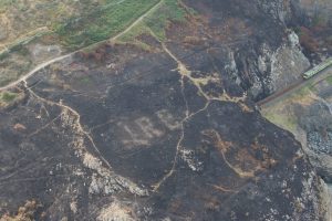
MAJOR UPDATE 6 AUGUST 2018 – EIRE 8, Bray Head, Wicklow
The Eire sign at Bray Head has been revealed following a major fire there in July 2018. The record for the sign is here, and the map has been updated accordingly.
Key pages:
A map of still extant Neutrality signs is on Google Maps here.
Images of the signs visible on Google and Bing Maps are sorted by county here.
Updates to the site are posted here.
Introduction to this project:
Many years ago, in a piece about the lighthouses on the coast of Brittany, I saw a comment that the lighthouses were to tell the mariner where he was, and not just to warn him against rocks. In 1942-1943, a large number of signs were placed along the Irish coast to tell pilots where they were.
Today, we take high technology navigational aids for granted. In the 1940s, GPS did not exist. In 1942-43, close to the locations of the coastal watch huts, signs were placed on the Irish coast to identify the land below as Eire, and not, for example, Great Britain or Northern Ireland. Shortly after the EIRE signs were constructed, mostly by the volunteers of the local Look Out Post (known in the documentation as LOPs), the identifying number of the relevant LOP was added, enhancing the signs’ value as a navigational aid. A list of LOPs, their locations and numbers were given to allied pilots thus allowing themselves to reduce the risk of crashing in the Republic of Ireland, and also, giving them greater detail on where they were.
Currently available information suggests the signs were really only of use during the day, although according to Michael Kennedy’s work on the Coastal Watch (Guarding Neutral Ireland, 2009), fires may have been lit near some of the signs during winter nights.
Approximately 85 of these signs were built. I don’t have an exact number. There were 83 coastal watch stations and I believe that at least two sites constructed two signs, namely Achill Island and Slieve League. In 2012, realising there was no list of the still existing signs, I decided to locate as many of them as could still be seen from commercially available satellite imagery. I have been fortunate to locate more than 30, all on the western coastline. The largest number of them are still to be seen on headlands in Donegal, where the greatest number of them have survived. Mayo has a significant number also
In researching this, I have learned a great deal about the coastal watch in Ireland during the Emergency, that great language by which we engaged in the myth that we were not at war. I have spent a great deal of time reviewing maps, satellite photographs and aerial photographs. A certain number of people have been very helpful in terms of locating these signs. Some of these people, I will not even know their real names.
Time is not kind to these installations but a number of them in Mayo, Donegal, Cork and Clare have been recently renovated.
Thank you for this very informative web page. I would be very pleased if you could help with some research I am working on. Where can I find information showing that lists of location numbers were given to allied pilots. Thank you
In the Irish Military Archives G2 files for crashed foreign aircraft there is in one of the American files a copy of a document recovered from an abandined B-17 which if I recall correctly either lists the numbers or explains that they are listed on the nav maps given to crews. This was an Air Transport Command, Ferry Division document. I think I have something in a file from US National Archives.
LOP No7 at Hawk Cliff inDalkey. I have been involved in this excavation and we are now ready to tell the world How many photos do you need – and what amount of text is best for your format? We spent 1700 hours on the project and will have an official dedication event this Summer. Many thanks. Des
Hello, this is a fascinating website and i’m very interested in gaining knowledge about these LOP’s and the EIRE markers, here’s a link a post I made to the Pillbox Study Group forum with pictures of the LOP at Clogherhead in County Louth, http://pillboxstudygroup.freeforums.org/clogherhead-lookout-posts-rep-of-ire-t732.html
Here is a link to a page on the history of Clogherhead and it mentions the existance of an EIRE marker near the lookout post, I have searched for this and I am yet to find it.
http://www.clogherhead.com/index.php?option=com_content&view=article&id=73&Itemid=80
I look forward to hearing from you
Found Eire 64 near Ciede Fields on north coast of Mayo at Ballycastle
Hi, their is an Eire sign in cleggan co Galway. It’s in bad shape but you can still see it
Sorry about delay just looked at this again yes it’s the same site it’s in very bad shape.is their any grants or something for doing them up
Did you get any info on any grants
Hi Cormac, can you give me any more clues exactly where? I’ve a possible site at 53.575565, -10.126698 but if it’s that, it’s in extremely bad repair. Otherwise, if you can give me directions with respect to the harbour or any other landmark in the area, that would be good. Thanks, Treasa
Hi,
Lops still survive in substantial ruin at Greenore point no 13, Carnsore point, no 14 and Kilmore Quay no 15 in Wexford.
The Eire signs are not visible but are believed to be still in existence under the soil. The search is on for them! BM
I would be interested if these turned up. I need to check but I understood many were removed if the land was usable for crops or farming and this was particularly an issue on the east and south east coast.
Great to hear, carnsore and Kilmore were the only 2 story lop built
It would be great to find both Eire signs or even pictures of them
I’ve found the location of EIRE 11 at Cahore Point Co. Wexford from this Photo on Instagram.
https://instagram.com/p/v_3npjxuza/
Location on Bing
https://www.bing.com/maps/?v=2&cp=52.564281~-6.194245&lvl=19&sty=h&form=LMLTCC
It’s not visible on bing might be gone or overgrown.
I’ve also put together a Wikipedia page on these Eire markings and Lookout Post’s.
https://en.wikipedia.org/wiki/Coast_Watching_Service
Fantastic – We have a mobile coffee shop at Banba’s Crown, Malin Head. The most asked question we get is “what does the 80 EIRE sign mean” We always explain, but now we have a list of all of them. Thanks
Between St. John’s Point(EIRE 70) and Carrigan Head (EIRE71) there is a mark at Drumanoo Head, Killybegs
http://maps.osi.ie/publicviewer/#V1,568821,873202,11,5
https://www.bing.com/maps/?v=2&cp=54.606101~-8.482781&lvl=19&sty=h&form=LMLTCC
also in County Wexford at Kilmichael Point LOP if you look at this point in the map you can posibly see an EIRE sign here http://maps.osi.ie/publicviewer/#V1,725336,666181,7,0 this might not be anything, it would probably require a visit to the location to confirm.
Sorry posted link to LOP site this is the location that i can see something on the ground.
http://maps.osi.ie/publicviewer/#V1,725372,666237,7,5
Hi, just a small point. Although Ireland was effectively a republic during the Emergency, it was only officially declared as such in 1949. At the time it was known as Éire, or, in the English language, Ireland.
EIR6 on Howth Head is clearly visible as a 20m diameter stone circle on Google Earth at 53° 22.966’N, 6° 3.145’W. I have not yet visited it – it is on farmland but it seems to be well maintained.
Dropped pin
https://goo.gl/maps/aPyGcMcLtvz
No 57 near roonagh pier in mayo.
I actually don’t have this one – I will get it added over the next few days.
At st johns point lighthouse there is an eire 10/ eire 70 marking cant work out which, but it looks as if it has recently been restored as there is fresh dig marks, concrete and paint although it looks like its not completely finished as the eire marking is only half painted. Was just interested in any info about this.
Thx
John
Thank you so much for this site, it’s brilliant. Found the one on Inis Mór last year, after a bit of a search.
This project travelled to the LOPs in recent years.
http://www.lookoutpost.com
Enjoy
The St Johns EIRE 70 has been fully restored. The EIRE is at a 90 degree angle to the 70 and a short distance from it. It has been restored using natural stone unpainted (unfinished?) whilst the 70 is painted white.
It can be seen (just about) in its pre-restored state on Google Earth.
Patrick
Is this site still being updated?
There is this other older site.
http://www.lookoutpost.com
Could be helpful in IDing structures
Hi we were in Downpatrick today. It reminded us that there was one in Loughros Point Ardara. Co. Donegal. It’s partially covered over now. We’re not sure what number accompanied it.
EIRE80 right up at Malian Head, easily accessible. It’s the first one I’ve come across. I will try and take photos of as many as I find on my trip around ireland
Malin Head was actually the first one I saw. At the time I had absolutely no idea what they were for.
There is one on The Great Blasket Island, up beside the watchtower ruins.
I am struggling to find this one. The aerial photographs for the Great Blasket on Google are cloudcovered, and the west side is not clear on the Microsoft photographs. I also have not been able to locate the watch tower ruins. Help would be appreciated.
Visible on Bing maps
Blasket Island
52.098325 -10.524778
Great Blasket
52.098217 -10.523980
Thanks for this – I will update the map and site accordingly.
http://jrnl.ie/4164681
Bray has re-emerged!!
Just listening to the news about the fire revealing the EIRE sign in Wicklow and it brought back memories of when I was a child staying with my aunt in toe head co cork just in front of her house the EIRE28 sign was there . She explained all about it to me I was fascinated. Thanks for the great web page
You’re welcome.
Saw this one recently, in great condition. No number spotted but should be 83 which is out of sequence as its between LOP 35 and LOP 36. https://goo.gl/maps/VZEqfnBn34q
I believe the associated lookout post was built later than the initial 82 look out posts. I’ve added it to the map and to the list for Kerry.
Have a look at Mizen Head at 51.452519. -9.814934 which is lower on the hillside to website location. Looks more likely to me but interested to see what you think.
I agree and have added it to the record for Mizen Head.
https://www.facebook.com/neatmedia/videos/245036829533063/
Bray Head being restored.
Can anyone shed light on why there is no fada on the E on any of them?
Just wondering if there were any markings along the border for aircraft to distinguish between Northern Ireland and Eire ?
Hi there.
I don’t actually know, to be honest with you. That being said, they shouldn’t have been approaching Northern Ireland from the wrong side of the border as it were…until the Donegal Air Corridor went into effect, I guess.
Have you any info on the Bundoran sign I advised you about last week.
Hi Declan,
Very good article in Irish Times Saturday re the sign in Dalkey (Eire -7) which I have seen.
Got me thinking about the Bundoran sign. The last time I was walking around Rougey had a look where I remember it was but not a sign – I guess it’s just been covered by vegetation. I had a look at a satellite image of the area as well but not enough definition to spot an outline. I wonder if the locals will want to ressurect it and make it an attraction. Judging by the state the shelters are in I somehow doubt it!!
Hope all good with you.
D
Fanad Head sign found by drone by TG4 cameraman yesterday.
Fanad Head Eire Sign accidentally found by TG4 cameraman !
Hi there – currently verifying the location and waiting for access to a photograph. Thanks for the update.
Smaller (earlier presumably) Eire sign visible on Black Head, Clare, just metres north of Eire 48 sign. Google and Bing.
Second sign on slieve league at 54.624140 -8.677216. Just visible on osi mao aerial 2005.
Found this on wikivisually.com .
Drumanoo head Donegal has Eire sign but doesn’t seem to have a corresponding LOP . Would be interesting to know how many extra Eire signs there really are!
Wondering if you found second sign in black head, Clare ?
Yep. There is a major photography update coming which will include it.
I am trying to find the location of the EIRE sign ajacent to the look-out post on Aughris head in Co Sligo, could anyone tell me where to look for information or which Government dept or agency could help me please , thank you.
I recommend starting with the Military Archives and Sligo County Council.
Great to see an excellent article and video about ÉIRE LOP 7 restored by Dalkey Tidy Towns in today’s Irish Times.
Eire 7 Dalkey restored.
Over 70 years ago my father showed me an EIRE sign on the cliff walk near Ballycotton. I’m wondering. Is there any record of this among the records?
The locations I have for signs in Cork are here; http://eiremarkings.org/category/counties/cork/
Ballycotton was sign number 22, and yes, it should exist in the records. There was a LOP there but I have no evidence that the sign itself is still in place.
Was up at LOP 36 Eask Head near Dingle today.
Eire sign was east of tower at 52.117576 -10.274336 according to landowners.
Each letter was built about 18 inches high. The E is still visible on Bing maps. Landowner said the rest of the stones were used to build walls along the cliff.
Thanks for this as I did not find this. Looking at it, it is in really bad repair. The re-use of stones is not unusual in Kerry – the sign in Brandon was used for the drystone walls there too. I will add it.
Hi there. Have you any idea where the Wire signs were in County Louth?
Hi Ciaran, I have not been able to locate them by site but I know they were located at the following locations:
Ballagan Point
Dunany Point
Clogherhead
I’ve been told the Clogherhead one is basically overgrown. I have no information regarding the other two.
Cahore Point 11 and Hook Head 16 found this week !