You are to be commended on the painstaking work you have undertaken in highlighting this important aspect of our history. Unfortunately the Watch House at Portacloy (known locally as Teachain a’ Watch) was severely damaged during a recent storm. We had contacted various agencies over the years to try and have it repaired but to no avail. Do you know who is responsible for these buildings? Any information you can provide would be much appreciated.
I really don’t know to be honest. If you have not already spoken to someone in the Office for Public Works, it might be worth contacting someone there. It is possible that Mayo County Council might have an interest but I imagine you’ve already spoken to them.
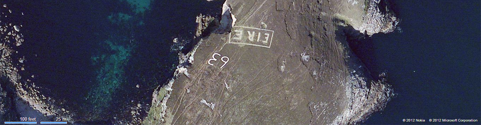
I am a Fáilte Ireland tour guide for Mayo & I knew 5 of these but was unaware of 2 more which are barely visible, 60 & 61,I will go hunting for them soon. I will ask Mayo Cócó what can be done about them. This is an important part of our heritage. Derek Davidson Tour Guide & Trekker at Walk West Ireland .
If you hear of any more of the Mayo signs getting renovated, I’d be grateful if you could let me know. I have been told that there is one on the northern side of Achill somewhere as well but that it has been completely overgrown. I’d appreciate information about that if you come across that locally. I could not find it on the aerial photographs when I searched for it.
These EIRE signs were also to alert German Pilots and crew who were conscientious objectors and who had overflown the UK, to ditch and parachute to safety. Many airmen lived at the Curragh Camp. They were allowed freedom during the day, eg. they often cycled the lanes and roads to enjoy the peace and quiet and then returned to the Curragh Camp for their curfew hour.
This is so cool! Seeing the visible mark of history on the land fascinates me, and I’m glad to see that someone else thinks it is too! Enjoying your hard work from Oregon, US!
There was one at the Rennies near Nohoval Co. Cork on the cliffs but a dangerous cliff and almost impossible to see the remains… Approx 51.716450, -8.344144
HI Imogen, I have had a look again at aerial photographs – I am guessing it is in very poor repair? I cannot see any evidence of it at the moment. A couple of the signs in Cork – Sheep Head is another example – are built in places where I’m astonished anyone would work.
You are to be commended on the painstaking work you have undertaken in highlighting this important aspect of our history. Unfortunately the Watch House at Portacloy (known locally as Teachain a’ Watch) was severely damaged during a recent storm. We had contacted various agencies over the years to try and have it repaired but to no avail. Do you know who is responsible for these buildings? Any information you can provide would be much appreciated.
Hi Treasa,
I really don’t know to be honest. If you have not already spoken to someone in the Office for Public Works, it might be worth contacting someone there. It is possible that Mayo County Council might have an interest but I imagine you’ve already spoken to them.
You are probably already aware but here’s another to add to your list:
http://www.thejournal.ie/world-war-ii-eire-sign-wicklow-fire-4164681-Aug2018/
I am a Fáilte Ireland tour guide for Mayo & I knew 5 of these but was unaware of 2 more which are barely visible, 60 & 61,I will go hunting for them soon. I will ask Mayo Cócó what can be done about them. This is an important part of our heritage. Derek Davidson Tour Guide & Trekker at Walk West Ireland .
If you hear of any more of the Mayo signs getting renovated, I’d be grateful if you could let me know. I have been told that there is one on the northern side of Achill somewhere as well but that it has been completely overgrown. I’d appreciate information about that if you come across that locally. I could not find it on the aerial photographs when I searched for it.
Hi,
Great website about a topic I was unaware of until this week’s publicity about the Bray Head sign. You might like to know that the Bray Head sign location is about a 1km south of where you have it no the map at the moment. Someone has helpfully already marked it on Google Maps:
https://www.google.com/maps/place/%C3%89ire+Sign+-+Bray+Head/@53.1757826,-6.076216,608m/data=!3m2!1e3!4b1!4m5!3m4!1s0x4867a9fdd601ea73:0x115c03e51b6276f3!8m2!3d53.1757826!4d-6.0740273
You can just about make out the outline on the pre-fire Google images once you know its there.
Thanks for this Cormac. I’ll get the map fixed.
These EIRE signs were also to alert German Pilots and crew who were conscientious objectors and who had overflown the UK, to ditch and parachute to safety. Many airmen lived at the Curragh Camp. They were allowed freedom during the day, eg. they often cycled the lanes and roads to enjoy the peace and quiet and then returned to the Curragh Camp for their curfew hour.
This is so cool! Seeing the visible mark of history on the land fascinates me, and I’m glad to see that someone else thinks it is too! Enjoying your hard work from Oregon, US!
Eire 7 currently being restored at hawk cliff in Dalkey.
Hi
I recently saw a programme on RTE about an Eire sign in Dalkey and was wondering if you had any furthet info on same please.
Love the site. The Slirve Leauge one shown here never had a number. Number 71 is a little farther south al Carriagen help. I hope this helps
Yes, this is interesting. We know there are a few around that were not numbered as such, but I don’t know very much about them.
There was one at the Rennies near Nohoval Co. Cork on the cliffs but a dangerous cliff and almost impossible to see the remains… Approx 51.716450, -8.344144
HI Imogen, I have had a look again at aerial photographs – I am guessing it is in very poor repair? I cannot see any evidence of it at the moment. A couple of the signs in Cork – Sheep Head is another example – are built in places where I’m astonished anyone would work.