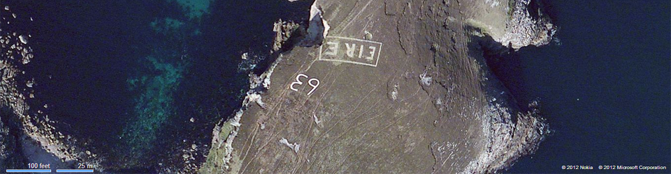
My name is Treasa Lynch and I put this site together when I realised there wasn’t an easily accessible list of the remaining EIRE signs available anywhere. When I started the project initially, I hoped to find around 12 signs still in place. At this point in time, I’m aware of about 30 in varying states of repair. The site in Mizen Head is in the very worst state of all; the sign on Saint John’s Point while comparatively complete, is barely visible on a map.
Several sites are starting to suffer damage owing to coastal erosion – Portacloy in Mayo is an example as is, in fact, the aforementioned Saint John’s Point. The sign at Mizen Head is little more than one letter and some stones.
Some sites have been renovated, namely Loop Head in County Clare, Baltimore in Cork and Melmore Head in Donegal to name a few. The numbers have disappeared from several sites.
I believe at least 84 signs were put in place in the 1940s and possibly more. In many respects, the 1940s isn’t that long ago, in many others, it is two generations ago. There cannot be many people left alive who worked the days on the coastal watch. While I recognise the impossibility of retaining all these sites, I believe it is important that we retain a few at least. They served several purposes. Folk memory, I am told from Brandon Point in Kerry, suggests the locals were told to build them to warn German pilots not to bomb this particular spit of rock which was neutral. The addition of the LOP numbers made them very clearly a navigational aid however, rather than a keep out sign.
I have only seen two signs in real life. The site in Malin Head is possibly the best known site at this point in time, but the marking near Black Head in County Clare is visible from the road. The work done in Loop Head has been the subject of a lot of media interest as well.
I’ve reviewed a lot of satellite imagery of the east coast looking for them there. I have seen photographs of the sign in Cahore Point so am sure they existed. But they are no longer in situ, possibly because the land was more valuable to be ploughed or built upon. There is a windfarm on Carnsore Point. The reappearance of the sign at Bray Head is a very unexpected bonus.
There are a couple of stages to this project:
- Identify the still existing sites visible from the satellite map services
- Provide the coordinates for the still existing sites
- Review the LOP log books in the military archives for mention of the building of the sites.
- Collect photographs of previously existing signs either from the 1940s and 1950s
If anyone has any information from family memory about the building of the signs, or, particularly, information regarding where more than one sign may have been built for a LOP as was the case for Slieve League and Achill Island, I’d really appreciate it. I’d particularly appreciate a clue as to where the second site on Achill Island is/was. I cannot find it. Given that I located the sign – practically invisible – on Saint John’s Point – it is hurting my pride that I might have missed this one.
August 2018 – I do not get to update this site as often as I used to but I am still interested in any additional material which helps with this project.
On your aerial photo of Wicklow Head the EIRE Sign (no. 9) is clearly visible at the base of the round tower.
I was involved in the search and subsequent cleaning of the Loophead sign. We whitewashed it exactly as it would have been in 1944. There was no trace of it when we started our search which was led by historian, Michael Kennedy, author of Guarding Neutral Ireland. He has a very interesting chapter p244 on the building of the signs. We have not yet exposed the Loophead number. It was no 45 but maybe the stones have gone missing. There were exactly 83 signs. What can cause some confusion is that the Irish Army issued instructions to the coastwatchers to build the signs without giving detail size and location. When Gen McKenna, Chief of Staff flew on an inspection tour around the coast of Ireland he realised that the signs were all different and some illegible so he instructed that they all be rebuilt to a certain size and in the correct location. While the stones from the old signs were usually used in the new ones older people with a vague memory of the building of the signs might direct you to the site of the original one. They were originally built at the instigation of Gray, the USA ambassador in Dublin who was annoyed that, when the inexperienced US pilots crash-landed in Ireland there was the possibility of them being interned if they were known to be on active duty. The numbers were added after they were built and the US Air Force pilots were given maps with the numbers so they could use them as navigational aids. The Loop head sign is now quite a tourist attraction.
Hi John,
Congratulations on clearing the Loop Head sign. I have been to see it.
There were 83 coastal watch stations but according to my research, the stations in Achill Island and in Slieve League in Donegal had two separate signs built for them. The second sign on Achill is buried according to locals, and both the signs in Slieve League were still visible until a few years ago. I’ve also been told there is a second sign linked to one of the west Cork locations but I have not yet located it. I’m aware of the confusion over minimum sizes – there’s a known photograph showing the two different signs which were built for Cahore Point which you can see on this page: http://www.castlearchdale.net/id29.html >>> it’s the image directly under the two maps. As far as I can ascertain, both those signs are gone.
I have read Michael Kennedy’s book. It is excellent. It, along with Tim Schmeltzer’s site have been invaluable to me.
Regards,
Treasa
I believe there was such a sign somewhere around Helvik Head in Co. Waterford.
Unfortunately the person who mentioned it has recently died, just before I came across this project.
I will endeavour to make enquiries in the coming months.
regards
M Walsh
The stones on bloody foreland are still visible , although they are not painted yet, another project .
We were in Slieve League on holiday a few years ago. Our bus driver told us about the signs and we were able to see the sign near the car park. I’m so pleased that you are working to restore this bit of WWII history and honor the men who participated in guarding the coast.
THANK YOU.
I would be delighted to know why the fada was left off ÉIRE. We can all make a mistake with our spelling, but to get it the name of the country wrong over 80 times seems strange.
Can anyone offer an insight?
Sign in very good condition less than 1 mile from Maghery, Dungloe in Donegal, visible from the castle/tower on high near cliffs.
Excelletn site
Great info on the signs
Worth looking at LOP records in Military Archives in Dublin for more information.
Hi Sean, I have been to the Military Archives to have a look at the LOP records – I found them fascinating on several fronts, not just related to the signs but for elements of Irish social history also. You know you can download one LOP logbook from each LOP site bar one?
Great site, thanks.
We went to site 54, Aughrusbeg, today. You could walk straight over it if it wasn’t pointed out, rocks in a rocky landscape. There was another sign, now demolished, two fields away. I guess this was one of the early incorrect size and site markers. The LOP was demolished approximately 30 years ago to make way for a water tank.
Hi.i am trying to pinpoint the LOP at Roguey Bundoran.Would it be possible that it could have you any idea what number it is
Kind Regards Emmet Travers